
See Beyond Limits
Survey & Drone Services for Mining, Construction & Infrastructure
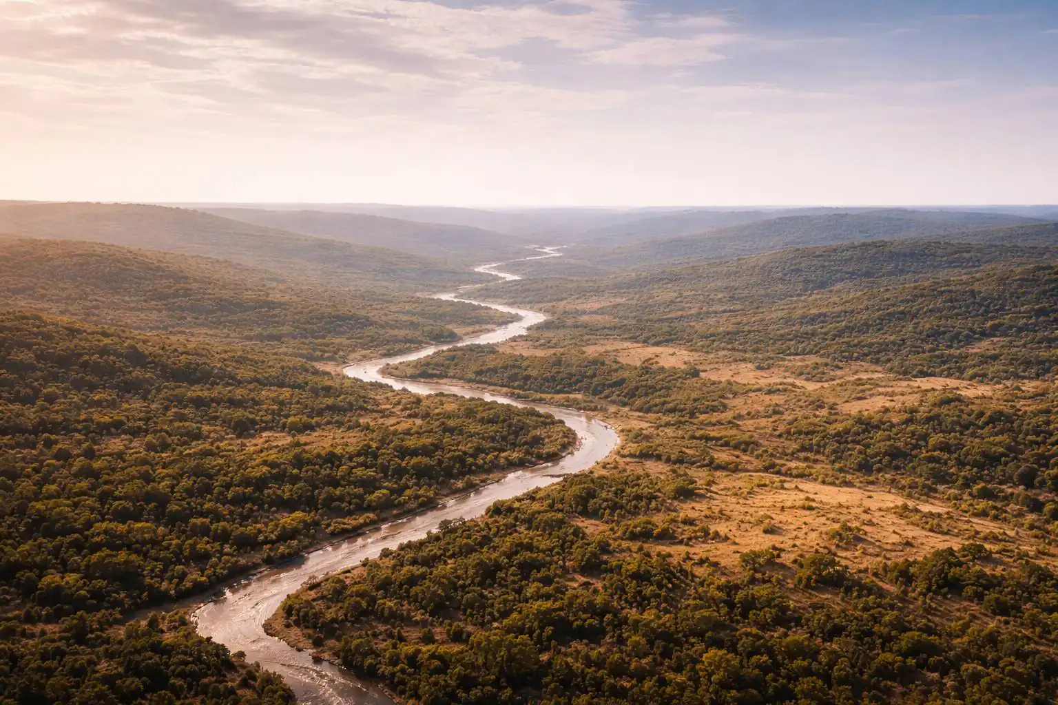
From ground-level GNSS control to aerial LiDAR and drone mapping — precision spatial data for every phase of your project.
Our Capabilities
End-to-End Spatial Intelligence
SitecFly combines ground survey expertise with advanced drone and remote sensing technology to deliver accurate, actionable spatial data across West Africa's mining and infrastructure sectors.
01
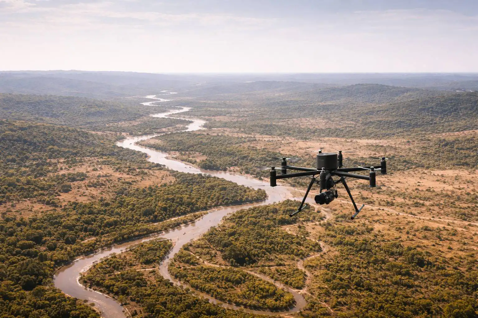
Drone Services
Aerial intelligence for site monitoring, mapping and inspection.
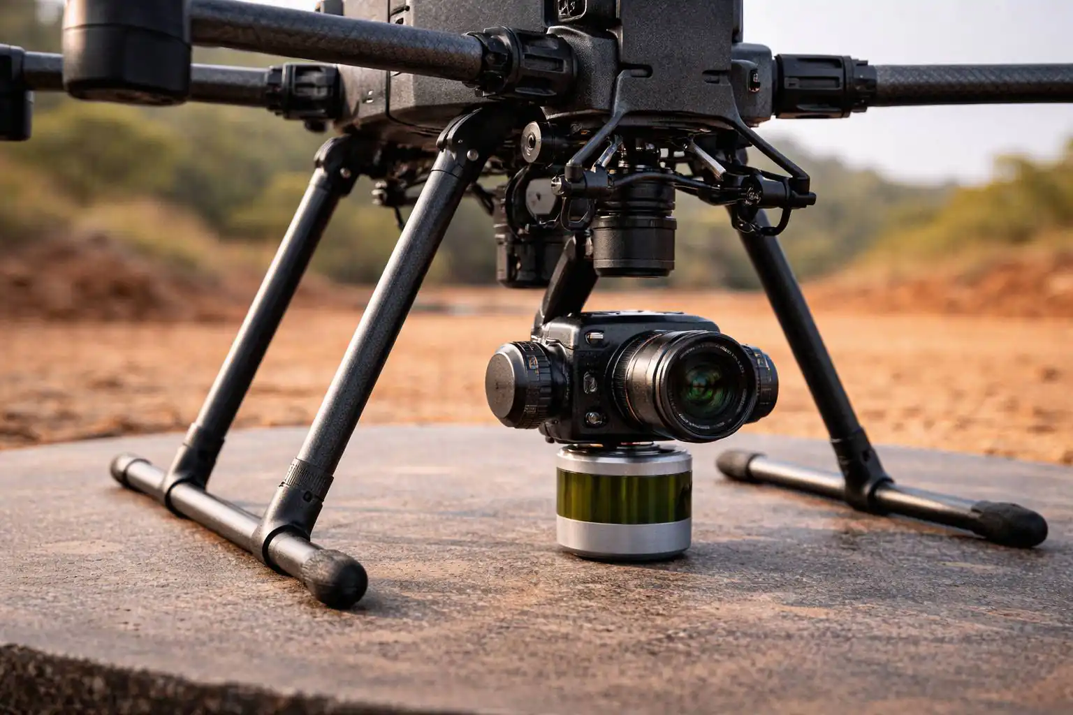
Drone Mapping & Photogrammetry
High-resolution orthomosaics, digital surface models and 3D point clouds from UAV-captured imagery.
Airborne LiDAR Scanning
Airborne LiDAR scanning for dense, accurate terrain and vegetation models — ideal for mining, forestry and corridor mapping.
Construction Monitoring
Regular aerial progress captures for earthworks tracking, volume calculations and visual reporting.
Solar Farm Inspection
Thermal and visual drone inspection of solar panel arrays for defect detection and performance monitoring. Part of our Solar Farm Performance Assurance programme.
Environmental Monitoring
Aerial surveys for environmental baseline studies, vegetation mapping, erosion tracking and inputs to environmental impact assessments.
Infrastructure Inspection
Close-range drone inspection of bridges, towers, pipelines and industrial structures — reducing risk and downtime.
Transmission & Distribution Line Inspection
Aerial inspection of HV/MV/LV line corridors — structural condition assessment, thermal fault detection and vegetation encroachment analysis using thermal imaging and LiDAR-enabled platforms. Deliverables include annotated defect reports, thermal imagery and GIS-compatible corridor datasets.
Aerial Photography & Videography
Professional-grade aerial imagery and video for project documentation, marketing and stakeholder reporting.
02
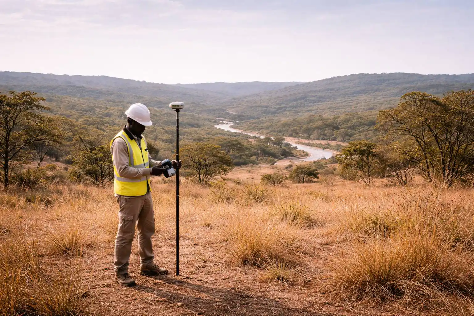
Ground Survey
Geodetic control and field survey for engineering-grade accuracy.
GNSS Station Setup & Management
Deployment and management of GNSS base stations and rover networks for centimetre-level positioning on project sites.
Benchmark Establishment
Installation and precise levelling of geodetic benchmarks and control networks for long-term project reference.
Topographic Surveys
Detailed ground surveys for site design, earthworks planning and engineering analysis using total stations and GNSS.
Cadastral Surveys
Boundary surveys and land demarcation for property registration, concession mapping and land-use planning.
03
Specialised Services
Advanced spatial solutions for complex project requirements.
Bathymetric Surveys
Underwater topographic surveys of rivers, reservoirs and coastal zones using sonar and echo-sounding technology.
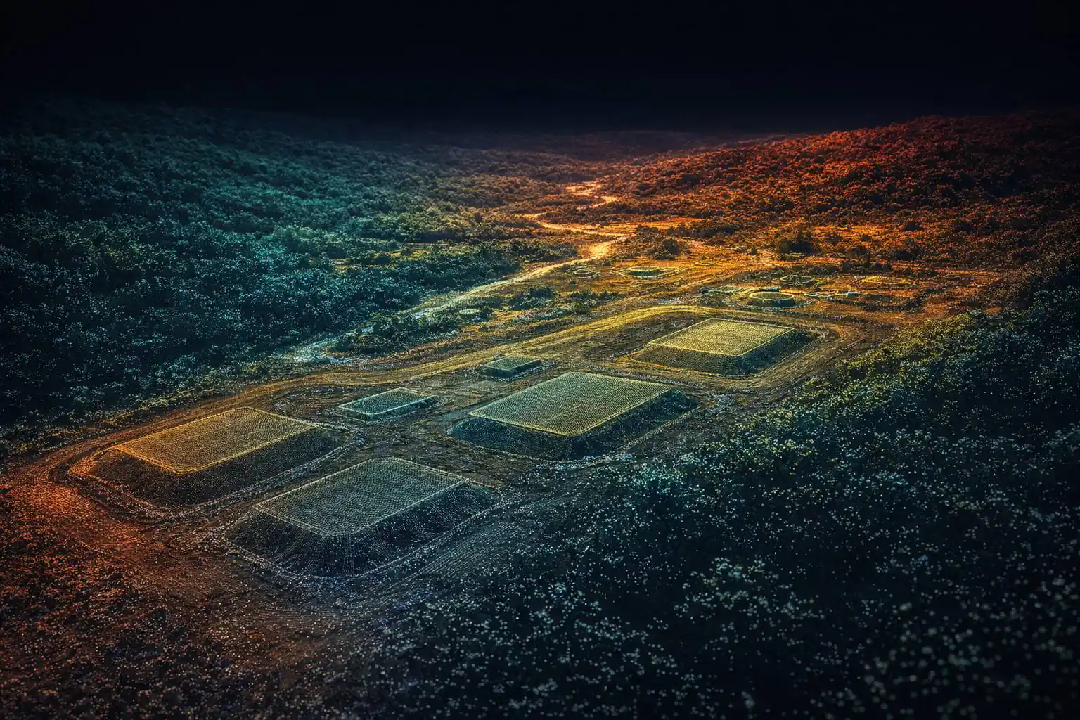
Volume Calculations
Accurate cut-and-fill computations from drone or ground survey data for earthworks, stockpiles and mine pit tracking. Volumes are reported against a defined base surface; tonnage is derived from client-confirmed bulk density.
GIS Data Management & Analysis
Spatial database development, map production and geospatial analysis for project planning and operational decision-making.
Flagship Programme
Solar Farm Performance Assurance
Inspection, cleaning & performance optimisation for utility-scale solar installations.
The Problem: Dust Costs Production
Solar farms in the Sahel operate in some of the harshest conditions for PV systems on earth. Fine laterite dust, Harmattan winds and intense thermal stress create a relentless cycle of performance degradation.
In the Sahel, unmanaged soiling can destroy over a third of production. A structured programme recovers this lost revenue.
Cleaning Operations
Performance Recovery
A dedicated on-site cleaning team with professional mechanical rotating brush systems and mobile water tanks, sized to match your farm's capacity.
Mechanical Brushes
Professional rotating soft-bristle systems designed for solar panels.
Adaptive Frequency
Cleaning cadence calibrated to seasonal dust levels and soiling data.
GPS-Tracked Coverage
Every route tracked and documented for full coverage verification.
Panel Protection
Demineralised water prevents mineral deposits on panel surfaces.
Right-Sized Crews
Team sized for complete coverage within the required cycle time.
Proven Recovery
Before/after production comparison confirms the effect of every clean.
Adaptive Cleaning Cadence
Frequency matched to real conditions.
| Season | Period | Dust Level | Frequency | Crew Mode |
|---|---|---|---|---|
| Harmattan | Dec–Feb | Extreme | Continuous / daily | Full deployment |
| Dry Season | Mar–May | High | Every 3–5 days | Standard rotation |
| Rainy Season | Jun–Sep | Moderate | Weekly or as needed | Reduced crew |
| Transition | Oct–Nov | Variable | Twice weekly (average) | Flexible scaling |
Thermal Inspection
Asset Health Monitoring
Comprehensive aerial thermal imaging — full radiometric analysis of your installation delivered as an engineering-grade report.
Thermal Orthomosaic
High-resolution radiometric maps of the entire installation.
Hotspot Detection
Severity classification with GPS coordinates for every detected anomaly.
Defect Identification
Activated bypass diodes, PID patterns, hotspots and disconnected or underperforming strings detected early. Cell microcracks require electroluminescence testing, available as a complementary service.
Trend Analysis
Inspection-to-inspection comparison tracks degradation over each six-month cycle.
Action Register
Severity-ranked corrective actions, prioritised by return on investment.
Professional Reports
Engineering PDF deliverables for owners and lenders.
Service Packages
Half-Yearly Thermal Assessment
Every 6 months
- Full thermal drone inspection
- Anomaly maps & severity log
- Engineering PDF report
Cleaning Operations
Continuous
- Dedicated on-site crew
- Mechanical brush & water tank
- Adaptive seasonal frequency
Annual Performance Review
Every 12 months
- Combined thermal & cleaning history
- Trend analysis & degradation tracking
- Next-year recommendations
Why This Programme Pays for Itself
Recovered Revenue
With 4–7% average global energy loss from soiling, the revenue impact is substantial and recurring. Structured cleaning recovers this directly.
Early Fault Detection
Thermal reporting identifies hotspots and underperforming modules before they turn into larger losses or safety incidents.
Faster & Repeatable
Structured inspection workflows deliver lower inspection time, safer execution and reliable comparability across reporting periods.
The financial case is simple: recovering even 4–7% of output more than pays for the programme.
Ready to Protect Your Solar Investment?
We recommend starting with a preliminary site visit to understand your farm's layout, current O&M practices and performance targets.

Ready to See Beyond Limits?
Tell us about your survey or mapping requirements and our team will scope the right solution for your project.